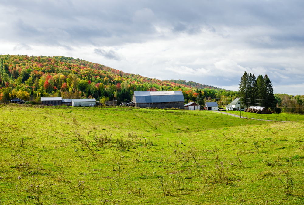
Canada’s grasslands are vitally important ecosystems. They’re home to hundreds of plants and animals, including many species at risk, and they are superheroes for carbon sequestration, nutrient cycling, water storage and pollination.
They’re also one of the most endangered ecosystems on the planet, with reports indicating that approximately 80 to 85 per cent of Canada’s native grasslands have already disappeared. They continue to be under threat from land conversion, climate change and other factors. However, knowing the exact loss is difficult to determine.
The Canadian Forage and Grassland Association (CFGA) is currently leading a project that will help address this challenge. The National Grassland Inventory Project will see the development of an inventory that will map Canada’s native and tame grasslands and track their changes regularly.
Read Also

Ask a Lawyer: What the Canada-China trade deal means for farmers
A Canada-China preliminary trade agreement reduces tariffs on canola seed, canola meal and peas, but some tariffs remain unchanged, leaving gaps for producers.
Stakeholder engagement
The first step was discovering exactly what stakeholders wanted in a national grassland inventory. They include federal, provincial and territorial governments, livestock producers and their organizations, non-governmental organizations, land trust organizations, academic institutions and Indigenous organizations.
[RELATED] Canadian Cattlemen: A wider vision for grassland conservation
CFGA contracted the services of Barbara Kishchuk of Science Consultation Services to conduct stakeholder engagement and a policy analysis. She says stakeholders identified three over-arching needs:
1. To establish consistent definitions of the grasslands to be mapped, including differentiating native and tame grasslands. This will provide clarity about what is being mapped, and how and where the information can be applied.
2. That data used to create the national inventory is standardized across jurisdictions and is broadly accessible. This will provide confidence in the mapping products and facilitate use of the National Grassland Inventory for different applications.
3. That the national inventory have the capability to be updated at intervals in the future. This will allow stakeholders to identify trends and monitor rates of grassland change.
Classifying grasslands
Don Faber-Langendoen, senior ecologist and conservation methods co-ordinator for NatureServe, is assisting with the grassland classification portion of the project, which is using the Canadian National Vegetation Classification (CNVC) as its framework. In development since 2000 and supported by NatureServe Canada, the CNVC provides provincial and territorial conservation data centres with a consistent ecosystem classification for their province and territory, as well as across Canada.
“In order to really assess the status of Canadian grasslands, we want a classification that isn’t limited to jurisdiction because you get different classifications in every jurisdiction,” says Faber-Langendoen. “A consistent approach allows us to assess the different grassland types wherever they occur.”
To date, the team has produced a draft mid-scale classification for all of Canada’s grasslands that provinces and territories can connect to with their provincial details. However, while some provinces have spent a lot of time classifying their grasslands at finer scales, they are inconsistent between provinces, so Faber-Langendoen says they need to link them at what they call the ‘group level.’
“What we want to do is to obtain all of the provincial and territorial grassland classifications and formally link them to these mid-levels so that whatever information they’ve collected using their classification, we can bring together so we can look at the status and trends in the grasslands.”
Another feature is a conservation status assessment that ranks the degree to which the grasslands are at risk of collapse, be that from heavy grazing, overgrazing, invasive species, conversion to annual crops or fragmentation or conversion caused by development.
“Some of the grasslands are, at this point, so rare that they’re at risk of being lost,” says Faber-Langendoen. “We have some provisional understanding of their risk, but we’re trying to formalize that. That’s the second part of our work, to really document how at risk they are.”
[RELATED] Canadian Cattlemen: More grass, less gas, more money
Remote sensing
Faber-Langendoen’s team is working with the project’s remote-sensing team to determine how best to link the classification of grasslands to the mapping process. Nasem Badreldin, the founder of Grassland Analytical and an assistant professor of digital agronomy at the University of Manitoba, is leading the remote-sensing team, as well as providing training and mentorship to graduate students working on the project.
Badreldin’s team is responsible for identifying the different grassland categories using optical and radar remote-sensing technology, which increases the accuracy of identifying the different grassland species. Using satellite-based images from space-borne sensors, they can map the native, tame and mixed grassland over Canada with the highest possible resolution.
One challenge is getting an accurate classification as they work to differentiate between the different grasslands. To address this, they are using a two-pronged approach.
“One of them is understanding the spectral signature of each land cover class,” says Badreldin, explaining that native grassland has a specific spectral signature different to that of tame and mixed grasslands.
The second approach is using artificial intelligence (AI) to help differentiate between the three systems. This makes it important for the ground-truthing teams in each province to be consistent as well as for everyone to take the same steps when collecting climate data and using the same satellite data.
Badreldin says the opportunity — and the challenge — is to try to map grasslands with the highest spatial resolution while also providing reasonable accuracy. The aim is above 90 per cent-prediction accuracy.
To date, they have mapped 12-million hectares in Manitoba with a spatial resolution of 10 metres, achieving the 90 per cent and above overall prediction accuracy using AI-based approaches. Manitoba has been the arena for testing the system. The next step is to repeat the mapping in other provinces.
Ground-truth data collection
On the ground, Heather Peat Hamm, a plant ecologist in Saskatchewan, is leading the teams conducting the ground-truth data survey to determine the extent of grasslands in Saskatchewan and Manitoba. During the 2022 field season, they completed ground-truthing in the Aspen Parkland ecoregion of Saskatchewan and targeted five areas in Manitoba with higher levels of perennial cover, completing sampling of these areas in mid-August.
“With a lush year in 2022, we were able to extend the survey season later than was possible in the dry summer of 2021,” says Peat Hamm, explaining that in both provinces, sites were categorized as native, tame, mixed or shrubs. “Cropland and tree sites were also included in the Saskatchewan survey to match with previous survey work in other ecoregions.”
They also recorded information about the existing dominant species in both provinces.
“This data may start the process of coarsely linking sites to ecosite categories, in the case of native sites, or will help understand whether a site is tame because of intentional seeding of forages or because of increases in invasive grass species,” says Peat Hamm. “Next season will see the extension of this sampling into other areas in both provinces.”
She says it is important for landowners to know that the collected data will not be reported, but will be used to develop the model that relates geospatial data to what native and tame grasslands is actually on the ground.
CFGA executive director Cedric MacLeod says the ultimate result of a national grassland inventory will be the ability to track change and understand where Canada is losing grasslands and why.
“Once we have a consistent inventory we can start to pinpoint those areas of most rapid loss in Canada,” says MacLeod. “This will allow us to have a more in-depth conversation around programs or policies that may need to be enacted in order to stem this loss.”
– This article was originally published as a supplement in the 2022 Forage & Grassland Guide.