Forecast issued Jan. 14, covering Jan. 14 to 21, 2026
Highlights
- Alberta can expect a continuation of sunny skies and milder temperatures with little to no precipitation.
- Manitoba will see temperature ‘whiplash’ with thermometers jumping between above freezing and -20 degrees early in the forecast period.
- Over the weekend and early next week, most of Saskatchewan and Manitoba can expect a return to cold temperatures.
Overview
Last week’s expected warmer and quieter weather mostly played out as expected. It was definitely warmer, and most places across the Prairies saw at least a day or two of above-freezing temperatures.
Read Also
Canadian drought conditions improve in March
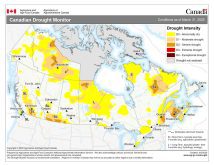
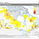
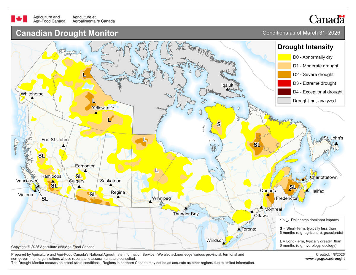
Normal to above normal precipitation in March helped moisture conditions improve across much of Canada, according to the latest Canadian Drought Monitor data from Agriculture and Agri-Food Canada
Overall, it was a quiet week weather-wise. But, as is often the case when weak systems dominate the pattern, the weather models missed a couple of systems. These tracked through the central and eastern Prairies during the second half of the forecast period.
These systems were not particularly strong and did not bring much in the way of accumulating precipitation. However, the presence of warm air created some issues, including pockets of light freezing rain and ice pellets.
For this forecast period, we are starting with a fairly sharp ridge of high pressure over Western Canada and a deep trough of low pressure over Ontario. This setup will keep Alberta and the western half of Saskatchewan in milder air, while Manitoba sees a quick return to more winter-like temperatures.
More weather coverage: Lightning gives and takes in Prairie fields
The western ridge is forecast to push eastward and collapse southward on Thursday. While this will allow milder air to return to the eastern Prairies, it will also let slightly cooler air filter into western regions. This brief cooldown does not look like it will last long, as the weather models suggest the western ridge will attempt to rebuild over the weekend.
The strong trough of low pressure over Ontario is setting the stage for an interesting weather pattern across Manitoba and eastern Saskatchewan on Thursday and Friday. A strong area of low pressure is forecast to develop over the Yukon on Wednesday before tracking eastward across the southern Arctic. On Thursday, as this low encounters the Ontario trough, it’s expected to quickly drop southward into northwestern Ontario. This is a rather unusual track for a system.
While this low will lack deep moisture, it will bring periods of snow to eastern Saskatchewan and to southern and central Manitoba on Thursday as a warm front pushes through. Expect snow again on Friday as the main low tracks by the region.
Cold Arctic high pressure will then slide southward into the eastern Prairies over the weekend and into the first part of next week. This will bring a return to average to below-average temperatures.
Over Alberta, the building ridge of high pressure looks to keep temperatures mild through the weekend, with a slow cooldown early next week as the upper ridge gradually weakens.
Alberta
With an upper ridge of high pressure dominating most of this forecast period, expect a continuation of sunny skies and very mild temperatures. Daytime highs across southern Alberta are expected to reach the low to mid-teens on Wednesday, with central and northern regions warming into the 5 to 10 °C range.
A strong area of low pressure tracking across the Arctic on Thursday will help temporarily shove the ridge southward, allowing cooler air to move in. Daytime highs on Thursday and Friday will be roughly 10 °C cooler than on Wednesday.
This cooldown will be short-lived, as weather models show the upper ridge rebuilding across the province on Saturday. Daytime highs across the south should push back toward double digits, while central and northern regions warm to around the +5 °C mark.
On Sunday, Arctic high pressure is forecast to drop southeastward into the eastern Prairies. Depending on its exact track, slightly cooler air could move back into Alberta early next week. Little to no precipitation is expected during this forecast period.
Saskatchewan and Manitoba
As outlined in the general forecast, an interesting weather pattern is expected to impact Manitoba and the eastern half of Saskatchewan on Thursday and Friday.
A strong area of low pressure is forecast to track across the southern Arctic on Thursday, pushing a warm front across the Prairies. This will help maintain mild temperatures across Saskatchewan, while Manitoba experiences temperature whiplash, with readings jumping from around +5 °C earlier in the week, to near -20 °C overnight Wednesday, and then back above freezing by Thursday.
More weather coverage: Hail research hopes to benefit potato growers
As the warm front moves through, some snow is expected, with a couple of centimeters likely.
On Friday, the main low will quickly drop south to southeast from the Arctic, reaching the Lake Superior region by midday. This system will bring occasional periods of light snow along with fairly strong northerly winds. Given the recent melting and episodes of freezing rain, the existing snowpack will not be easily moved, so any blowing snow will be limited to new snowfall. At this point, the system does not appear particularly productive, with most regions expected to see between 2 and 5 cm of snow.
Over the weekend and into at least the first half of next week, cold Arctic high pressure will spread across the eastern and central Prairies. Expect plenty of sunshine and cold temperatures, with daytime highs across Manitoba and eastern Saskatchewan near -15 °C and overnight lows falling to around -25 °C.
Western Saskatchewan will remain milder, thanks to persistent upper-level ridging over Alberta.