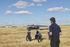
When Chris Neeser began to design a research project on the use of unmanned aerial vehicles (UAVs) in crop scouting, he wondered if anyone would be willing to fund it.
“This was different from a typical research project,” says Neeser, a research scientist with Alberta Agriculture and Forestry’s Crop Diversification Centre, South, in Brooks. “There was no hypothesis to test, no new production method or product to look at.” It was, as he says, a straight-up assessment of UAV technology and its application on the farm.
Read Also
Ask a Lawyer: What the Canada-China trade deal means for farmers
A Canada-China preliminary trade agreement reduces tariffs on canola seed, canola meal and peas, but some tariffs remain unchanged, leaving gaps for producers.
He needn’t have worried. The questions he wanted to ask about UAVs — what they can and cannot do, and their cost/benefit as a scouting tool — were questions a lot of other people wanted answered, too.
In the end, seven organizations came to the table to fund Neeser’s two-year study. Tellingly, all of them, including Western Grains Research Foundation, are grower-funded groups — an indication of how strongly UAV technology has captured imaginations and desire to see their on-farm potential realized.
Getting past the marketing hype
What prompted Neeser to do this research in the first place was the increased marketing of UAVs to growers as the “must-have” new farm tool. “The offering at the time was these NDVI maps and what they could show happening in fields,” he says.
At its simplest, normalized difference vegetation index (NDVI) maps show whether or not a target area contains green vegetation (NDVI maps have been generated by satellite for decades). This marketing suggested that UAVs could generate these maps quickly and easily, allowing growers to get a bird’s-eye view of their fields to identify areas that need attention and take quick action.
What Neeser and his team found, however, was a process a bit more complicated than that. The UAV itself (its ability to stay on course at an even speed, even in windy conditions), the flight control system, camera quality and capability and, finally, the software and technical ability to process collected imagery and collate it into some kind of readable, high-resolution image within a reasonable time frame were all factors in the efficacy and usefulness of using a UAV to scout for weeds and disease.
Neeser and his team decided to measure three specific aspects of UAV technology: its usefulness for early weed scouting, for disease scouting, and its cost.
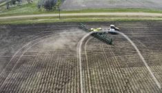
They used a fixed-wing UAV and captured images three times during the season in six crops (two fields each of barley, canola, field peas, seed alfalfa, potatoes and spring wheat). The first flights, conducted in late May and early June, were focused on weed scouting, while the second two flights (late July and mid-August to early September) assessed the ability to spot crop disease with UAVs.
Mixed results and lots of potential
So what did they find? “As far as weeds go, the problem is a lack of image resolution. We don’t have enough resolution to detect them,” says Neeser. “We need to see weeds when they’re tiny, and that just doesn’t show up.”
He explains that NDVI maps are essentially a collection of pixels. In this study, UAV images were taken at 180 metres above the ground with a modified Canon PowerShot SX260 HS camera, with the result that each on-screen pixel represented a 6 x 6-centimetre area of that ground.
That might sound like a pretty good close-up, but at that range, and the ability to identify which pixels are crop and which are weeds is a challenge. Identifying individual weed seedlings and even weed species was impossible.
Still, he sees potential for this technology to develop weed-density maps by using an algorithm that removes the pixels representing crop rows so that any remaining pixels showing green indicate weeds. It’s an onerous process, though.
“Bottom line, we have the parts to build a system that would do this,” he says. “But how useful is a weed-density map just now? At this point, not so much, because we also need sprayers that can use those maps.” He adds that such sprayers exist, but the technology is still in its infancy.
On the disease scouting side, Neeser sees some more immediate application. “With crop diseases, we have enough resolution to see it’s there, but it can’t tell us what the disease is.”
Crop disease tends to create patches that are highly visible in the crop canopy from a height. Neeser thinks farmers could use those images to guide boots-on-the-ground physical inspections and treatment. One symptom of clubroot in canola, for example, is patches with a thin canopy. Flying a drone over a canola fields could reveal patches when they are still small and therefore difficult to detect by other means.
“The imagery would allow you to see small spots, gaps in the crop canopy, some of them small enough that you wouldn’t necessarily see them by walking the field,” Neeser explains. “You wouldn’t know what the disease was from the images, but you’d know where to look and where to test in the field.” You might even find that the patch was not caused by disease at all, which is still valuable to know.
It’s a more efficient way to scout for soil-borne disease that occurs in patches, he says, and it does offer growers a better chance of finding problem areas that warrant further investigation. “It’s a totally new approach to managing disease in specific areas.”
Worth the expense?
And what about the third aspect of the study? Given its current limitations, is UAV technology worth the expense? Well, yes and no.
Neeser is the first to admit that UAVs, including all the software and image-making support they require, are constantly evolving and getting cheaper. Even so, the cost and the extra layer of technical expertise they add is mostly being borne by independent crop advisers who, he says, increasingly see adding UAVs to their arsenal as a necessary cost of doing business and staying competitive.
He thinks UAVs can complement the other high-tech crop surveillance tool: satellite imagery (which is where NDVI mapping began). Satellite imagery is better and faster than it once was, and is far less expensive to use. “No way can a drone compete with a satellite on cost,” he says. But they can help each other. “Satellites will do the field mapping and pick out patterns within fields, and UAVs will assist with the close up inspection.”
Having said that, UAVs are in their infancy when it comes to farm work, and Neeser is keen to see what the future holds. “Right now, UAVs are a great ad hoc crop inspection tool,” he says. “They provide information that’s useful and immediately actionable [in terms of further scouting], but not written down anywhere.
“It’s like where computers were in the ’80s,” he says, recalling the hesitancy, curiosity and finally warm embrace of computers as an integral farm business tool.
“There’s a sense that’s where we’re at with UAVs just now,” Neeser says. “A lot of farmers are buying these things because they’re intrigued by them; then they find applications for them.”
WGRF is a farmer-funded and directed non-profit organization investing in agricultural research that benefits producers in Western Canada. For over 30 years the WGRF board has given producers a voice in agricultural research funding decisions. WGRF manages an Endowment Fund and the wheat and barley variety development checkoff funds, investing over $14 million annually into variety development and field crop research. WGRF brings the research spending power of all farmers in Western Canada together, maximizing the returns they see from crop research.
Chris Neeser’s UAV research was funded by:
- Alberta Crop Industry Development Fund
- Alberta Canola Producers Commission
- Alberta Pulse
- Alberta Alfalfa Seed Commission
- Alberta Wheat Commission
- Potato Growers of Alberta
- Western Grains Research Foundation