
Even with some uncertainty in the last forecast, the weather models did a surprisingly good job. At one point it looked like I was going to have to send out an update as the models started trending toward a cooler pattern, but they quickly reversed back to a warm pattern. This brought the expected heat to much of southern Saskatchewan and Manitoba, with daytime highs pushing into the upper 20s and at least one official 30 C reading. As forecasted, the cooler air did work into the west as the upper ridge transitioned to the east, with temperatures dropping into the mid-teens in Alberta on Tuesday.
Read Also
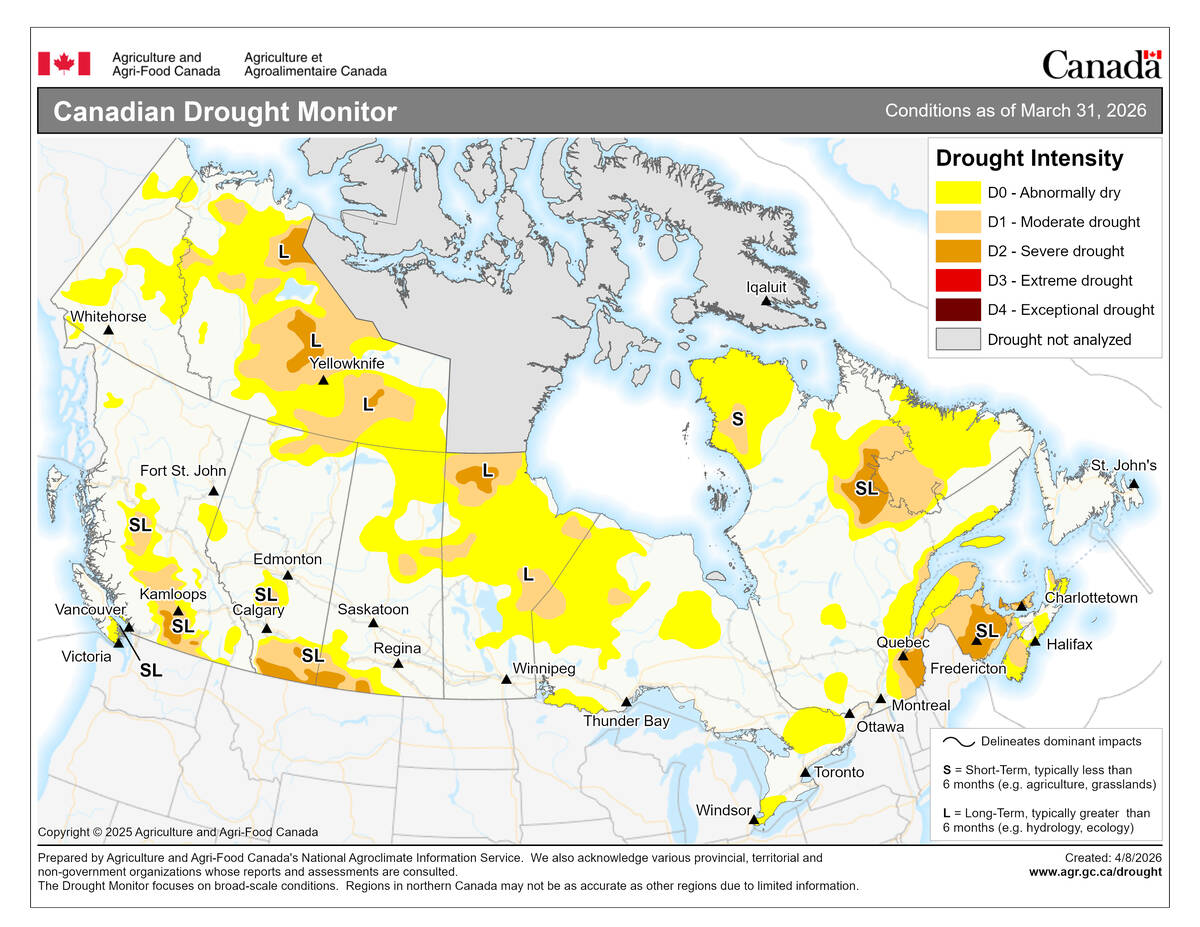
Canadian drought conditions improve in March
Normal to above normal precipitation in March helped moisture conditions improve across much of Canada, according to the latest Canadian Drought Monitor data from Agriculture and Agri-Food Canada
For this forecast period, it is looking like most of the Prairies will be seasonable, warm and dry with high pressure mostly dominating the region. The only fly in the ointment is a small area of low pressure that is forecasted to spin up over Montana and then slowly move eastward into North Dakota by the weekend. Depending on the strength, speed and exact track of this low, southern Manitoba may end up with a cloudy, damp end of the week.
Daytime highs look to be in the upper teens to low 20s on most days right across the Prairies, with a few mid-20s possible. Overnight lows will also be mild, ranging from 7 to 12 C on most nights. These temperatures are about 4 to 6 C above the long-term average for this time of the year.
Alberta
High pressure is forecasted to build over this region during the second half of this week. A weak disturbance on Wednesday may bring some clouds along with the chance of a shower over west-central regions but the high should clear things out by Thursday, bringing plenty of sunshine and seasonably warm temperatures. Expect daytime highs to be in the mid-teens to start, warming toward the low 20s by Saturday. The warmest temperatures will be in the east, with the coolest readings over far western regions.
Over the weekend the weather models show a weak area of low pressure developing over central Alberta. This low looks to only bring a mix of sun and clouds to central and northern regions on late Sunday and through the day Monday, with only a few showers expected. The low will quickly move off to the northeast by the end of the day Monday, bringing a return to sunny and dry conditions to finish off this forecast period.
Saskatchewan
Much like the last couple of forecast periods, Saskatchewan looks to miss out on any of the major weather makers. The weather models currently show weak high pressure dominating the region right through until Saturday, bringing plenty of sunshine and warm fall temperatures. Daytime highs are forecasted to start out in the upper teens on Wednesday and then warm into the low 20s from Thursday through to at least Saturday.
On Saturday, an area of low pressure south of the border may bring some clouds and showers to far southern regions, but confidence in this part of the forecast is low. If this does take place, southern regions will see cooler temperatures, thanks to the cloud cover. The low is forecasted to move off to the east by Monday, bringing a return to sunshine across the south. Further north, the weak Alberta low will be tracking through, resulting in partly cloudy skies with maybe the odd shower. The southerly flow ahead of this low will help to push warm air into the region with some hints of daytime highs in the mid-twenties on Tuesday or Wednesday.
Manitoba
Tough forecast for this region, due to the potential slow-moving low forecasted to track through the Dakotas late this week and over the weekend. This forecast period will start off sunny and warm, with one more day of mid-20s temperatures expected. On Thursday and Friday, moisture moving northward ahead of the developing low could start to bring clouds and showers to southern regions. Exact timing of any showers is up in the air right now, as confidence in the timing of this is low. Temperatures look to remain mild despite the cloud cover, with daytime highs forecasted to be in the low 20s on both Thursday and Friday. Of course, regions that do end up seeing any persistent showers will be cooler.
Over the weekend the weather models show the low slowly spinning itself out over the Dakotas. Just how far north this system will go bears watching. Currently it looks like best chance of rain will be over western regions on Saturday and into Sunday morning before the low starts to weaken. On Sunday, far southern regions look to see the best chance of rain. Temperatures will still be warm to the north of this system, with daytime highs remaining in the low 20s.
The low should finally weaken by Monday or Tuesday allowing high pressure to build in to end this forecast period. This high will bring a return of sunshine and warm temperatures across all regions with daytime highs forecasted to remain in the 20 to 25 C range with no hints of overnight frost.
— Daniel Bezte is a teacher by profession with a B.A. (Hon.) in geography, specializing in climatology from the University of Winnipeg. He operates a computerized weather station near Birds Hill Park, Man. Contact him via email with your questions and comments.